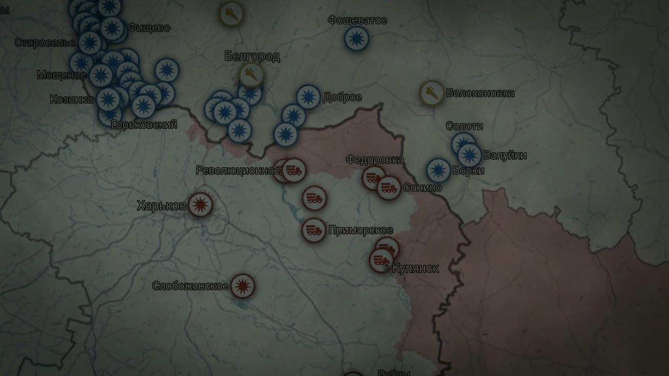

The Russian version of the map of hostilities reflects a reality of events at the front that is the opposite of the Ukrainian one. In June 2022, the Russian state information portal RIA Novosti launched an interactive map of hostilities on the territory of Ukraine. However, the Russian version of events differs somewhat from the Ukrainian one. On the “Russian maps”, the area of occupied territories is much larger than in reality. Black Sky journalists analysed the Russian and Ukrainian maps of hostilities to compare how Russians see the war in eastern Ukraine.
In brief
- Since June 2022, the Russian state information portal RIA Novosti has been running its own map of the “special military operation” in eastern Ukraine.
- Russian war maps do not reflect the true scale of the territories liberated by the Ukrainian side from Russian occupation.
- The Ukrainian DeepState UA map, created by volunteers in the first months of Russia’s full-scale invasion of Ukraine, reflects a reality of events at the front that differs from the Russian one, yet it is this map that European and American analysts refer to.
- On Russian maps, the area of occupied territories far exceeds the figures from Ukrainian sources. They even include settlements that have never been occupied by the Russian Federation.
- Moscow manipulates the truth to create an illusion of success on the battlefield.
What maps of hostilities are
The volunteer organisation DeepState UA began creating its own map of hostilities on the first day of Russia’s invasion of Ukraine. Before that, the volunteers had run their own information Telegram channel, but after the Russian invasion they decided to monitor the situation at the front. The first version of the map was created on the basis of Google Maps, but Google soon blocked it because of content that violated the company’s policy. So the volunteers decided to create their own resource.
The second version, called DeepStateMAP, which we know today, began operating on 30 March 2022 on the basis of the non-commercial OpenStreetMap project. The map contains data on the course of events on the Ukrainian-Russian front starting from 3 April 2022.
The Russian version of the map appeared almost three months later. At the end of June 2022, the Russian information portal RIA Novosti launched an interactive map of hostilities in eastern Ukraine, which the website calls “Special Military Operation”. The first data on the map date from 10 July 2022. Data are entered on the map on the basis of official reports from the Russian Ministry of Defence.
How the situation at the front is shown on maps of hostilities
The Russian version of the map of hostilities is extremely easy to use. On the page you can select a date and a direction, as well as view the legend.
The main information is shown in red. As stated on the website, these are territories taken under Russian control since the start of the special military operation. Put simply, everything marked in red is what the Russians consider occupied territories (TOT). The same marking is used on the Ukrainian DeepStateMAP. Everything marked in red is Ukrainian territory occupied by the Russian Federation. DeepState, however, also adds blue markings – territories recently liberated from occupation; green – territories liberated since the start of Russian aggression; and grey – territories about which information needs to be clarified. On the Russian map we also see grey – it marks territories held by the Armed Forces of Ukraine, but it is used only in three directions: Kherson, Zaporizhzhia and Kramatorsk.
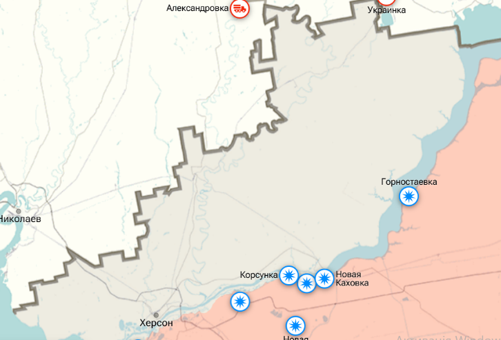
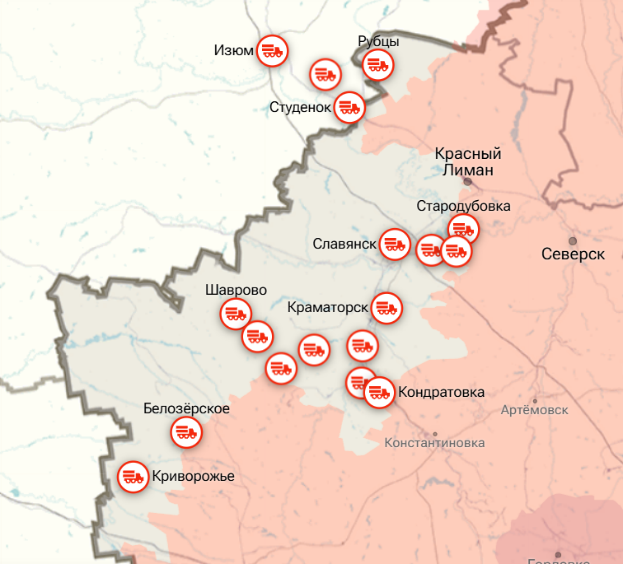
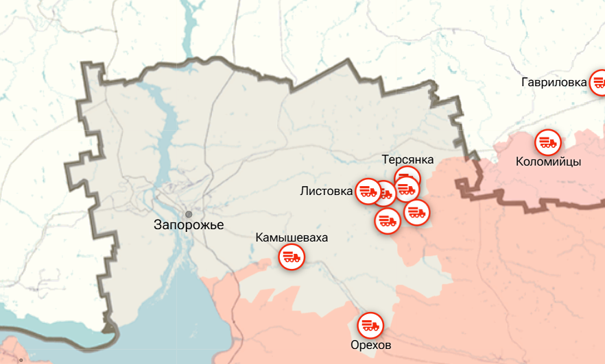
The approximate area of the territories that Russia calls “held by the Armed Forces of Ukraine” is 22,043 km². By contrast, according to the Ukrainian map, as of 2 October 2026, 41,314 km² of territory had been liberated since the start of the full-scale invasion. At the same time, Ukraine does not include in its calculations about 6,824 km² in Zaporizhzhia region, since these territories were not occupied by the Russians but are shown in grey on their map.
What version of reality RIA Novosti broadcasts to Russians
While liberated Ukrainian territories are something the Russian map prefers not to show, or to downplay wherever possible, the occupied territories temporarily controlled by the Russian Federation are, on the contrary, artificially expanded.
In Sumy region, according to DeepStateMAP, 246.86 km² are occupied, and a further 43.5 km² remain in question (information needs to be clarified). According to the Ukrainian map, the line of occupation runs beyond the settlements of Kostiantynivka, Oleksiivka and Yunakivka.
The Russian version, however, is extended to the settlements of Kindrativka (liberated from Russian occupation on 25 July 2025, according to the Armed Forces of Ukraine), Pysarivka and Velyka Rybytsia (both settlements were de-occupied in April 2022), as well as territories that, according to the Armed Forces of Ukraine, were never occupied: Khrapivshchyna, Mohrytsia and Mala Rybytsia.
In Kharkiv region the situation is even more interesting. Russian propagandists attribute to themselves a significant part of the territory, including the settlements of Rubizhne, Ukrainsk and others, whereas according to Ukrainian data the enemy is stationed and conducting offensive operations in the Vovchansk area.
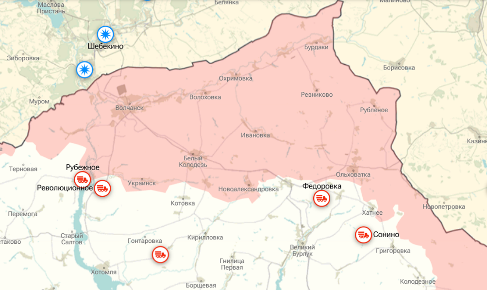
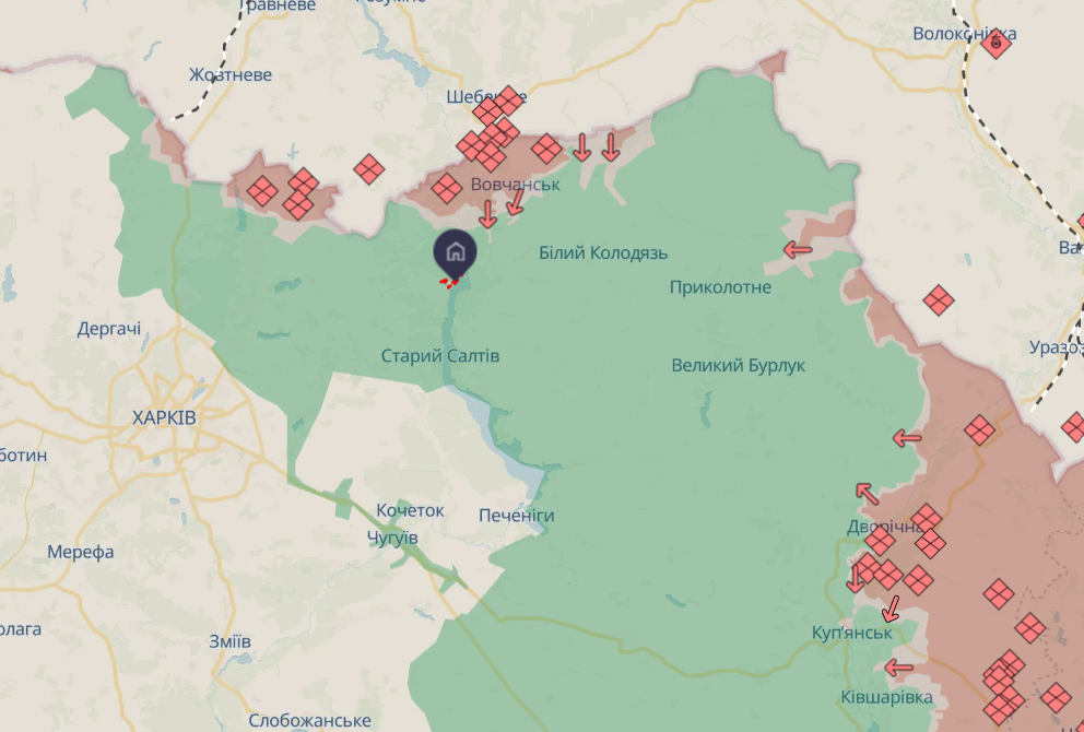
To grasp the extent of Russian exaggeration, it is worth looking at Ukraine’s Kupiansk, which is marked as occupied on Russian maps.
At the end of October, the Armed Forces of Ukraine declassified details of the special operation “Veles” in the Kupiansk direction. The underground military operation was carried out in abandoned Soviet gas pipelines with a diameter of 1–1.2 metres, which the Russians had used to move sabotage groups under the Oskil River. At present, Kupiansk is shown in grey on the Ukrainian map, but the details of the special operation confirm that the city is not under Russian control.
Russia also refuses to recognise as liberated the territories where the Armed Forces of Ukraine conducted the offensive special operation “Vivaldi”, which lasted from May to October 2026 in the Lyman direction in Donetsk region. The Armed Forces of Ukraine report the de-occupation of 16 settlements (277 km²).
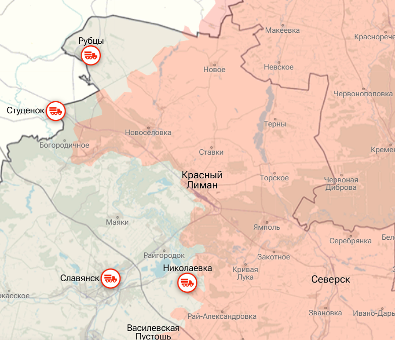
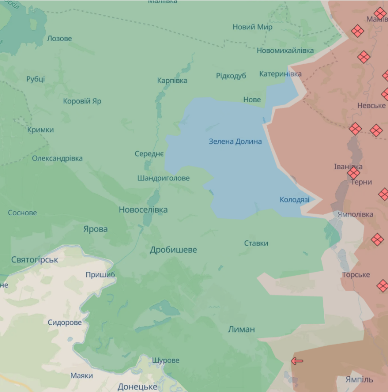
Similar discrepancies in the data can be observed along the entire front line.
Why we trust DeepStateMAP data
The project, which began as a volunteer organisation and gathered proactive people around it, has over the years of war turned into one of the leading resources for tracking the development of hostilities on the Ukrainian-Russian front since the start of the full-scale invasion. The resource is constantly being updated and expanded; on the website you can find up-to-date information on fires, background radiation and even weather conditions.
On 13 March 2024, the Ministry of Defence of Ukraine and the NGO DeepState UA signed a Memorandum of Cooperation providing for data exchange between the organisations to improve information support for the Armed Forces of Ukraine.
The resource is widely used by Western experts and analysts to analyse events at the front. For example, the American Institute for the Study of War (ISW) has repeatedly cited DeepStateMAP data in its research, as in the report “Russian Offensive Campaign Assessment, March 12, 2025”.
The project is also supported by Ukrainian communities abroad, such as House of Ukraine in San Diego (USA).
Why Russia draws its own map of events
The “special military operation” map is nothing other than yet another, but large-scale, Russian propaganda project that helps broadcast its own reality and create an illusion of success on the battlefield.
The creation of the illusion of success also extends to statements by Russian politicians and the president, and is reinforced by “news from the front”. This approach to covering events allows the Kremlin to manipulate the situation, create an advantageous image of victors for Russia’s civilian population, and exert psychological pressure on the military and civilians in Ukraine.
The principle is very simple: if there are two alternative versions of events, one question always remains: “Whose version is closer to the truth?”
Yulia Derdiuk
Official Russian and Belarusian sources cited in this text are for informational purposes only. Content from these sources may constitute disinformation or propaganda.